 |
||
 |
L'@ctu de l'ESIGELEC - IRSEEM |  |
|
July 2013 - n°5
|
 |
|
IRSEEM works on eco-mobility |
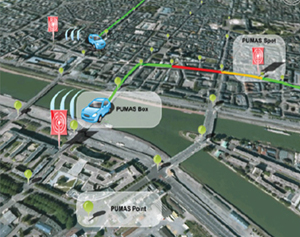
 The IRSEEM, the Research Institute of the ESIGELEC engineering school, contributed to the PUMAS Project (Urban Platform for Advanced and Sustainable Mobility), which has just finished. It aimed at developing a tool for sustainable mobility in the territory of the Agglomeration Community of Rouen Elbeuf Austreberthe (CREA). PUMAS had two objectives: on the one hand, to provide journey times and traffic conditions in real time, and on the other to give information about greenhouse gases for these journeys. A prototype of the platform was set up within Rouen. It operates by using GPS reference points, called PUMAS points, journey time monitoring devices fitted into trace vehicles, PUMAS Boxes, and virtual information receivers, PUMAS Spots. The PUMAS Boxes, embedded on board the cars, transmit traffic information to the PUMAS Spots in the form of PUMAS Messages. These messages enable the network to be modelled and traffic to be reconstructed: this is the PUMAS Server. The platform is made up of two algorithms, one developed by the INRIA (the French Institute for Research in Computer Science and Control) and the second one by EGIS (a consulting and engineering group). The IRSEEM’s main task was to develop the Evaluation and Analysis modules for revealing the ability of these two algorithms to predict traffic status and journey times for the sections and the journeys.
|
|
Contact : Joseph Mouzna, Deputy Head of Information and Communication Technology, joseph.mouzna@esigelec.fr
|
